These are imaginary lines drawn on maps and globes to help us determine our location. Each line has it’s own number, and where two lines cross, there is a set of numbers associated with that location called a coordinate. It’s a lot like playing battleship, where you use numbers and letters to find where you think the other player’s pieces might be.
The earth is round so we measure latitude and longitude with degrees just like we did with our compass. Lines of Latitude are referred to as Parallels of Latitude, because all of these lines are parallel to each other. The latitude which most people are familiar with is the equator. This is 0 degrees latitude and it divides the world into the Northern and Southern hemispheres. The North Pole is referred to as latitude 90 degrees north.
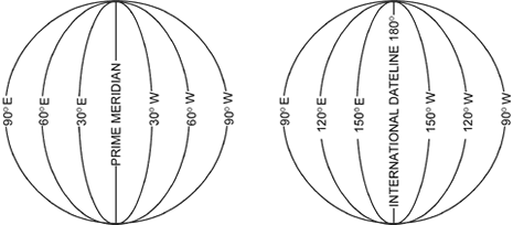
Lines of Longitude are referred to as Meridians of Longitude. These lines are not parallel to each other. They come closer and closer to each other as they approach the north and south poles, where they all meet. Zero degrees longitude is referred to as the Prime Meridian, and it passes through Greenwich England. The reason zero passes through Greenwich is because the English were some of the first people to begin using latitude and longitude as they traveled throughout the world and, at the time, Greenwich was an important center for the study of science and astronomy.
When we measure distances on land, we use smaller and smaller measurements to make things more and more accurate. For example, miles can be divided into yards, which can be divided into feet, which can be divided into inches. When we measure things using latitude and longitude, we start with the big measurement of degrees, and go smaller and smaller by using minutes and seconds. There are 60 seconds in a minute, and 60 minutes in a degree. These terms can be a little confusing because the degrees don’t have anything to do with temperature, and the minutes, and seconds don’t have anything to do with time.
Nautical miles are what we use to measure distance as we travel on the water. It is different from the measurement of a mile that we use on land, which is sometimes called a statute mile. A statute mile is 5280 feet, but a nautical mile is 6067.1 feet. Although they are very close the difference is very important, because one minute of latitude is equal to one nautical mile.
Questions:
Claudius Ptolemaeus, also known as Ptolemy, was a roman scholar who lived from 90 to 170 AD. He was the first person to place a grid system on a map and use the same grid system for the entire planet.
Ecuador, Columbia, Brazil, Uganda, Kenya, Somalia and Borneo are some of the countries that you will find along the equator.